Pictures: http://www.bestlibrary.org/files/life-in-upper-canada.pdf
Farming: 1st image since there is a wooden house with lots of trees and stumps in the area. There are crops by the house that look like plants. I assume this, because it is in a forest basically and the crops have a fence mostly around them.
Social Class: 12th image since a whole group of people walking around and looking at the parliament building where all the upper class people go to and are allowed to go.
Loyalty to Britain: 5th image since it has nice water with british ships going by representing the the British flag on the pole.
Land Issues: 4th image there are lots of tree stumps right by a lake with animals wandering about. It proves they need to make the land more nicer.
Religion: 11th picture, because someone is meeting and introducing themselves to a guy outside the jail area. There religion could be they always go to that part of Toronto and meet people since that is looks like a nice big area, which people like to shop and walk down and go to the church.
Wednesday, 26 September 2012
Tuesday, 25 September 2012
Tuesday, 18 September 2012
Nova Scotia in the Appalachian Region
Nova Scotia in the Appalachian Region
1. Within Nova Scotia alone there is 452, 800 people working in all the natural resource industries. In the major industry coal mining consists of 11,200 people.
2. The coal industry which is the a really big industry is compared to forestry since from coal mining brings in $238 million in Canadian money. The main coal mining area is located on Cape Breton Island. The Forest industry brings in $4.2 million in the whole year.
3. MANS is a big company called “The Mining Association of Nova Scotia.” It is located Bedford in Nova Scotia. They extract, refine and they also produce things that people need in their daily life. The Lafarge Plant is a really important plant in the mining association since it supplies most of the cement for roads so people can drive. It also makes trails so people can go on a path either for biking or walking. They make cement from limestone, which is nearby. The plant uses byproducts from steel and petroleum as other materials. They can keep the materials out of the waste stream and the use cuts down the need for virgin materials, energy demands and can improve cement performances.

Mining at the Conrad Brothers quarry trying to find minerals of iron, copper, lead, and gold, which is produced to create a economic development of opportunities for a growing population.
Resources:
http://www.statcan.gc.ca/tables-tableaux/sum-som/l01/cst01/labor21a-eng.htm
http://library.thinkquest.org/6370/Mi11.htm
http://www.novascotialife.com/chartermembers/mans
http://www.ns.dailybusinessbuzz.ca/September-2011/Mining-in-Nova-Scotia/2011-09-07/article-2742154/Guest-Spot%3A-The-Mining-Association-of-Nova-Scotia/1
Monday, 17 September 2012
Global Warming and Climate Change in Canada
1. Global Warming is a huge problem in Canada since if the climate changes then either glaciers will crumble and place will get very try. Wild animals will not go explore that much they will stay around on land more and might harm the humans, since they have no where else to go.
2. Arctic Region: It is a big problem in the arctic region because polar bears will not go and explore that often if the ice and snow melts. If that happens then polar bears will harm humans more often than usual. When ice and glaciers melt they will have a big effect on damaging and destroying homes, buildings, and roads. If roads get damaged then trucks with food and other sorts of items will not be delivered to important areas. Lots of bears will die and starve since they do not have ice to hunt and walk on.
Interior Plains: It will get very hot in the summer if the climate gets hotter which means super hot houses which people would not want to live in and dead burnt grass all over the plains. All the lakes will get very warm.
Canadien Shield: It will get very hot since there is no oceans near by and the increase of flooding and storms will go on which will hurt many of people and wipe out houses. This all will turn into a disaster and all the water from the arctic will come down the the east side of Canada. Everyone will want to move and get out of the east side so they don't get caught up in this huge mess.
The Cordillera: In British Columbia it will be more warm since we have the Pacific Ocean right by BC.The survival rates of spawning salmon will get higher and more pests will come out.
St. Lawrence Lower Region: This Region will have less flooding but will mostly be the same as the Canadian Shield.
Appalachian Region: This region will have lots of flooding and maybe storms since it is on east coast but it will not be so hot since the Atlantic Ocean is right by it.
Friday, 14 September 2012
The Cordillera
- Is made of parallel mountain ranges separated by a series of plateaus, trenches, and valleys in BC and Yukon.
- The landscape involves dormant volcanoes, glaciers, ice fields. This is part of a chain of mountains that stretches from Alaska to Chile.
- The Interior Plateau, Rocky and Coast mountain ranges are the youngest landforms all around Canada.
- Plate Collision and plate tectonics formed the landforms that caused the earth’s crust to buckle, pushing, and folding volcanic rocks into mountains.
- The mountainous landscape we see today is caused by a erosion that is from rivers and glaciers.
- Geological processes left rich mineral deposits, such as copper, gold, and coal.
- Forestry and major industry is a major part in the Cordillera region.
- Deposits that went in the valleys formed rich, fertile soils of areas like the Fraser River Valley.
- Before buildings in Vancouver of roads and railways, the river was vital transportation route.
- The rich deposits of gold and coal resulted in booms that helped develop BC as a province.
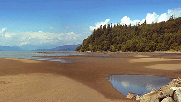
This symbolizes the landform of the beach.

The largest mountain on BC with jagged peaks.
Wednesday, 12 September 2012
5 Themes of Geography on Port Coquitlam
In class today we were introduced the 5 themes of geography. They are in the order of location, place, region, movement, and human & environmental interaction. We learned the defintion of each one and we needed to show using a example of each.
Now I need to use the five themes and give examples from Port Coquitlam:
Location
Absolute: Riverside Secondary School is 2215 Reeve Street, Port Coquitlam, BC V3C 6K8
Relative: Riverside Secondary is west from Lion Park and the Creek
Place
Physical Landscape: Colony Farms is in Poco
Cultural Landscape: Port Coquitlam Recreation Complex
Regions
Formal: Fraser River
Functional: The Sun is the distribution area of a newspaper in Poco
Perceptual: Have no movie theatres and are a small town.
Movement
Globalization: Television and music could be used, seen, and heard all over the world such as Poco.
Human & Environmental Interaction
Human interaction with the environment: New single homes development on Citadel Drive and a bigger entrance to the highway construction on the Mary Hill Bypass. Since this is occurring there will be more people and it is changing the environment by more noise and people.
Subscribe to:
Comments (Atom)